This example of Keyline Designs is in the Australian Environmental Industry Development Network Reference Site Directory.
First there is a summery, then the main report with photos.
A rural property in central Queensland has an irrigation dam that has never fully-filled by run-off from its natural catchment. Meanwhile, valuable stormwater run-off in adjacent catchments was only partially utilised by small stock dams. Thus wasting a valuable resource and exaggerating flood peaks.
The property used Yeomans Keyline Design interconnection principles to design and install graded, open channels that direct storm water run-off from a new dam site in the adjacent catchment to the original irrigation dam.
Keyline Designs, PO Box 3289, Southport, Qld., 4215. Ph 07 5591
6281 Fax 07 5527 0847
Email: yeomans@keyline.com.au and Internet web site is
https://www.keyline.com.au
Click here to Email to Ken
Yeomans OR
Go to Keyline Designs Homepage
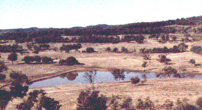
"The Plains", Mundubbera road Murgon, QLD
Run-off water from drought breaking rains are needed to bring this system on line. So read the testimony in the Technical Report below.
Tallangatta Valley Victoria; Delegate NSW; North Richmond, NSW; Frankland, Western Australia.
"Carisbrooke", Winton, QLD. 1990 Queensland Land Management and Conservation Award.
Technical Details
Keyline Agriculture
Keyline agriculture was initiated in 1944 by P.A. Yeomans on his farm at Richmond NSW. Keyline improves farm productivity under arid Australian conditions. The Keyline system developed the use of:
'The Plains'
'The Plains' is 1,550 ha of gently undulating land in the Burnett
region of Queensland. The property is used for cattle grazing,
lot feeding and cereal grain production. Timber plantations are
being developed.
A main 500 ML water storage dam already existed on the property,
constructed in 1983. It is low in the landscape, has virtually
no land below it (within the property) that can be irrigated by
gravity and its natural catchment area has proved inadequate to
ever fill the dam.
'The Plains' Keyline System
Keyline planning for the property started in 1991 following the
owners initial concern with failing contour banks and waterways.
Keyline Designs recognised two key criteria for improved farm
management. These were to augment the natural catchment of the
main dam with suitable diversion channels and to devise a way
to economically irrigate with water captured in the main dam.
Effluent from the cattle feed lot was also an issue to be addressed.
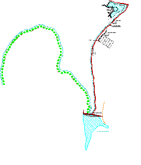
Keyline Earth Wall Dams
A 50 ML dam (known as Ken's Dam) was constructed in a large, adjacent
eastern catchment. The dam wall is 225 metres long and water backs
up 430 metres. Spillway overflow from this dam is directed to
the main dam via an open, graded diversion channel. The channel
runs slightly below contour and directs water from one catchment
to the other. Another diversion channel enters Ken's Dam from
the east, directing water into the dam from an eastern catchment.
This increases the catchment areas of all dams.
Keyline Channels
Keyline irrigation dams incorporate a Lockpipe System (a horizontal
pipeline) under the dam wall. The Lockpipe is positioned to release
all water from the dam by gravity flow. Ken's Dam releases water
to a north-flowing irrigation channel which will eventually extend
3,500 metres to the northern property boundary. The grade of Keyline
diversion and irrigation channels in undulating country is usually
1 in 300. The water flows at less than walking speed and soil
wash is minimal. Channels for hillside irrigation take the form
of an excavated trench. The maximum dimensions are: 1200mm width
at top; 600mm depth and; 600mm base width.
The channel passes below a cattle feedlot. Feedlot effluent is
directed to a small dam parallel to the irrigation channel. Effluent
and irrigation water can be mixed at will, and the irrigation
channel flow can be used to flush out the effluent dam if desired.
Effluent is therefore available for fertilising large areas of
the property.
Figure 1. Plan of Keyline irrigation system constructed
at 'The Plains'.
Irrigation Capacity
Ken's Dam, when full, can apply 50mm (2') of water to 100 ha (250
acres) of land. Applied water lasts about 10 to 14 days in summer
and less in windy conditions.
Rate of Irrigation
Given sufficient water in the dam and a sufficiently large diameter
lockpipe system, the rate of irrigation is dependent on the flow
capacity of the channel. At 'The Plains', flow from the lockpipe
system is regularly adjusted to maintain a full irrigation channel
as the dam empties. The theoretical peak flow capacity of the
irrigation channel is 2.2 ML per hour. The rate of irrigation
at this flow is over four hectares per hour.
Replenishing the Dam
Water in Ken's Dam can be replenished from the Main Dam by pumping
up to a feeder channel that drains back into Ken's Dam. The hydraulic
head between the two dams is ten metres.
Pumping at the rate of sixty litres per second will fill the dam
in ten days of continuous pumping. Electricity tariffs influence
the choice of pump installed. The option of using cheaper off-peak
power can reduce unit cost per kilowatt, however if pumping is
only for 8 hours each night then the pump and pipeline must carry
three times the flow. The capital costs of a larger pump, motor
and delivery line must be considered.
Keyline Pattern Irrigation
'Irrigation flags' are used to block the excavated irrigation channel. Flags usually consist of a three metre square sheet with a hem sown at opposite ends. A 100mm rigid pipe through one hem forms a bridge across the channel.
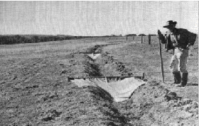
Figure 2. Keyline irrigation flags in place, awaiting
water.
A 3.5 m length of 6mm chain through the other hem keeps the cloth down under water. The weight of the water on the cloth and optional steel rod pegs driven into the ground at the end of the chain keep the flag in place.
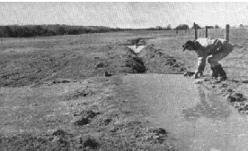
Figure 3. Water spills from the irrigation channel at
the first flag.
Usually three flags are used for each channel. Water spills from
the channel and then Keyline pattern cultivation controls water
movement over the surface.
Land preparation
Keyline Pattern Cultivation is all that is required unless the
landform has been altered from natural shapes. The most common
alteration to the natural form of the land is that produced by
old road lines and fences, especially when disk ploughs have resulted
in a step from one side of the fence to the other. Existing farm
roads are often badly positioned and have a detrimental effect
on surface flows. Relocation of some farm roads is common when
implementing a Keyline system.
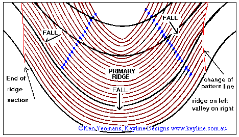
Keyline Pattern Cultivation
Keyline Pattern Cultivation was the breakthrough discovery by
P.A. Yeomans that enabled the controlled flood irrigation of undulating
land. The pattern of furrows it produces, controls the directional
drift of flood irrigation flows and run-off water. Cultivation
is done using narrow tyned, subsoil aerating rippers or chisel
type plows. The cultivation pattern looks like ordinary contour
ripping but it is actually an amplified contour pattern. The furrows
sweep higher as they cross valleys and lower as they wrap around
ridges. Keyline pattern cultivation enables a wide sheet of water
to flow down the middle of a ridge shape. It is mostly achieved
by working on the concave side of a contour guide line. On ridges
cultivation progresses up the slope towards the irrigation channel.
See the diagram.
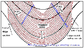
Figure 6. Keyline pattern cultivation on a ridge
shape. Load
enlarged view of this plan
On ridge shapes, cultivation of the area below the channel is not be done parallel to the irrigation channel but parallel upwards from a lower guide line. Cultivation parallel to the outside curve of a ridge will produce a pattern that will quickly strip water from the central ridge area. This little understood phenomena of the effect of cultivation pattern on surface flows probably best explains why the method of irrigation is so little used. When people attempt to copy what they see without understanding how it works they have little chance of success.
A full description of the technique is beyond the scope of this
paper.
Performance Characteristics
The Keyline Design system constructed on 'The Plains' is yet to
be fully tested because of extended drought conditions in the
area. Experience on other properties indicates the Keyline system
will improve irrigation potential significantly.
Elsewhere
A Keyline system installed on 'Carisbrooke' station, near Winton
in central Queensland, has proved invaluable during drought conditions.
The property has areas of impervious rocky terrain and a Keyline
diversion channel was constructed below these areas. Minor rains
in the middle of the drought were enough to produce run-off from
this impervious terrain. This run-off was diverted to Keyline
storage dams. This water was used to irrigate 65 hectares (160
acres) of cattle feed while other stations in the region had none.
The Keyline system effectively broke the drought for 'Carisbrooke'.
In the Kiewa Valley of North eastern Victoria in 1969 the local
dairy factory no longer needed to import milk from outside the
district to maintain dry season production. The extra milk came
as a result of Keyline irrigation projects on three local dairy
farms. Stock health also improved with Keyline soil treatment
methods.
Diversion channels
These may vary in size. The one in the next photograph is on Yobarnie in NSW. This channel carries flows diverted from a small creek.
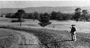
Figure 4. A newly
constructed
Keyline diversion channel to carry 13.5 ML per hour.
Contour tree belts
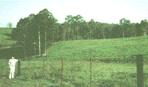
Figure 5. A timber
strip planted in 1953 as part of a Keyline system. Tree strips
are planted beside irrigation and diversion channels and on ridge
lines. Fences and roads follow the channels and neutral flow lines.
Winding contoured strips of timber, interspersed with pasture,
is a standard part of Keyline tree clearing procedures. The resulting
tiered forest belts enables stock to freely move from open country
to forest and back again. In normal conditions this reduces compaction
of the pasture and provides shelter for the stock both from heat
and cold. In one bush fire (wild fire) situation, sheep actually
saved themselves by avoiding the flames this way after the winding
timber strips broke up the fire front.
Capital and Operating Costs
| Capital Cost | |
| Keyline Design: | $2,177 |
| Dam Earthworks: | $11,232 for 8,230 m3 earth in the wall. |
| Lockpipe System: | $7,300 |
| Earth Channels: | $2,500 (approx. $1 per lineal metre to construct) |
| Operating Costs | |
| Electric Pump: | 60 L/s @ 10m head (to refill upper dam). |
| Diversion channels: | can last for years without maintenance. |
| Irrigation channels: | may need annual cleaning. |
| Pasture ripping: | Initially ripping is done before each or every second irrigation during the first irrigation season. Then annually for two years after that ripping is done only as needed. Correct stock grazing management is very important. |
Other Sites
Tallangatta Valley VIC; Kiewa Valley VIC; Delegate NSW; North
Richmond NSW; Frankland WA.
Awards and Site Visits
Awards
'Carisbrooke', Winton, QLD. 1990 Queensland Land Management and
Conservation Award.
Site Visits
Technical Report
Keyline is a proven set of principles that ensure "Sustainable Agriculture" in the full sense of the term. It was P.A. Yeomans an ex-mining engineer who first devised the scheme, which he named "Keyline". With Keyline we can sustain and develop land to produce its maximum capacity while nurturing, rather than stressing it in the process. Keyline makes it possible where other methods may fail.
Our first attempts at Keyline farming in 1957 on "Knockalong", (Southern Monaro, N.S.W.) proved to be an immediate success. We learned the benefit of non-inversion tyned cultivation in this light, steep, shale country. This was after dismal attempts at arresting run off by contour banks, which buried the little existing top soil, became a burrowing ground for rabbits and often tunnel-eroded to create erosion rather than prevent it. In addition, contour banks or contour ploughing do little for soil development. Water still runs down gullies unheeded.
Keyline cultivation on the other hand can run at as much as 45 degrees to the contour, the pattern running out and down onto adjoining ridges directing run off to be readily absorbed evenly over the total land surface. Gradually, poor ridges become fertile and soil depth increases.
When clearing, timber belts were left at 13 metre vertical intervals. These remained as permanent contour guide lines for patterned cultivation in the intervening cleared areas.
Dam sites were selected where maximum water storage is possible and the greatest potential for gravity irrigation can be realised on the hillside country below. Dams are interlinked with open channels, wherever possible, so that all water is harnessed and none wasted.
This is a far cry from so much of the old Soil Conservation philosophy where run off water was regarded as a problem to be got rid of "safely" down grassed waterways to eventually leave the farm unused. Even today it is distressing to see dams constructed with a open base pipe to mitigate flood fills slowly down gullies, instead of storing it for creative use in our often drought - ravaged nation.
With Keyline, all irrigation dams have a sizeable pipe through the base of the walls. These pipes have a gate-valve on the outlet. In times of need, the valve is opened to release water into the irrigation channel that usually has a fall of 1 in 300. By a series of "flag" moves the pattern-cultivated areas below the channel receives the equivalent of a good thunderstorm. The water also carries air down into the soil and plant growth is rapid and explosive in the days following.
You can have a green paradise while your neighbours look on with envy from their dry, brown landscapes. What is more, you can "finish" your stock to prime condition for market or grow a specific crop for harvesting.
Keyline planning involves the correct positioning of farm roads, timber belts, buildings, fences and pasture areas, all relative to each other in a common sense order of practicality. It is also aesthetically beautiful, being in harmony with nature and the landscape. Tree belts wind their way round hills and gullies in contours acting as wind breaks, firebreaks, erosion control and wild-life corridors. They do not follow regimental straight lines. Diversion banks often dissect deeply eroded wash out gullies caused by past mismanagement and carry storm water run off to dams for irrigation at a later date. The erosion is halted and the gullies healed. Below the dam or dams, soil develops more rapidly with the aid of gravity irrigation.
Keyline planning and design enable the full use of land potential by using our precious water resources creatively and not wastefully.
It is a system governed by the understanding of the important relationships of natural land forms and their relevance to the total scheme of things.
B.R. (Rix) Wright
'Knockalong', Delegate, N.S.W.
17/7/96
Business Profile
Name
Keyline Designs
Personnel
K.B. Yeomans H.D.A M.I.A.S.T. Gained Hawkesbury Diploma of Agriculture in
1969
and has been involved in the design of sustainable agriculture
systems since.
History
Keyline Designs was initiated in 1986 following the death of P.A.
Yeomans, who pioneered the work of Keyline agriculture in Australia
in the 1940s. Keyline Designs utilises the original Keyline principles
of on-farm water storage and soil improvement to develop sustainable
farm practises in Australia. Keyline systems have been applied
to small and large land holdings across Australia and overseas
by Keyline Designs since 1986. Ken Yeomans wrote 'Water for Every
Farm - Yeomans Keyline Plan' in 1993, which explains Keyline agriculture.
Capabilities/Expertise
Keyline Designs is a consulting business specialising in both
on-site property design and remote planning using electronic data
acquisition and digital terrain modelling.
The consultancy assists clients to apply Keyline principles to their land. Ken Yeomans often stays several days on-site planning and pegging out starting projects or ongoing developments.
Technical Publications
Yeomans, K.B. 1993. 'Water for Every Farm - Yeomans Keyline
Plan'. Keyline Designs, QLD.
Chapman, G. 1993. 'Economic Appraisal of the Use of Keyline
Farming Principles: Using a Case-study Property.' UNE Armidale
NSW Oct 1993
ABC TV. 1990. Western Australian Keyline property study: in 'A Question of Survival'. ABC TV series, screened Nov 1990.
Location Details
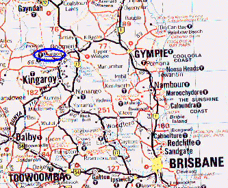
Murgon, Queensland
Contact Details
| Reference Sites | |
| Supplier | Directory Inquiries |
| Mr Ken Yeomans | Mr Ian Bergman |
| Principal consultant | Manager - Technology Diffusion Services |
| Keyline Designs | Environment Industry Development Network |
| PO Box 3289 | PO Box 237 |
| Southport QLD 4215 | Civic Square ACT 2608 |
| Ph: (07) 5591 6281 | Ph: (06) 248 3133 |
| Fax: (07) 5527 0847 | Fax: (06) 248 3806 |
| Email: info@keyline.com.au | Email: i.bergman@u030.aone.net.au |
| Internet: https://www.keyline.com.au |
Procurer
'The Plains'
Mundubbera Road
Murgon QLD 4605
This brochure is part of the Reference Sites Directory, produced by the Environment Industry Development Network. The aim of the Directory is to promote practical, on-site examples of Australian technology solutions to environmental problems.
![]() Back to Keyline Designs Homepage
Back to Keyline Designs Homepage
Counter started Feb 1998 You are visitor number: