
I will need to be able to identify your land to obtain the data. The street address is a good start. The Lot in Plan numbers may enable me to locate the property and see the boundary. The boundary line precisely constrains the design parameters.
The Keyline Designs Mapping Service processes the data from that website to produce Digital Elevation Models (DEM); more specifically, “bare-earth” DEM. Bare-earth means that in these DEMs existing buildings and trees are flattened, so that for example, a house appears as a bare pad and individual trees disappear. Forested areas look bumpy as can be seen the upper left corner of the following image, which was produced from survey data on a 1 x 1 metre grid.
Contour
intervals are optional pre-production. The map below shows major
contours at 10 metre intervals; intermediate contours at 5 metre and
minor contours at 1 metre intervals. Sub-metre contours are
possible and are used in flatter country or for details when zoomed into
areas of special interest in steeper country.
The colours in the DEM relate to height. The colour elevation spectrum is down from red (high) to blue (low). The shading helps reveal the 3D shape of the land.
The above image is a combination of a DEM file and a contour file. I usually supply this data as KMZ files for both image and vector data.
KMZ files open in Google Earth as overlays, which have variable transparency.
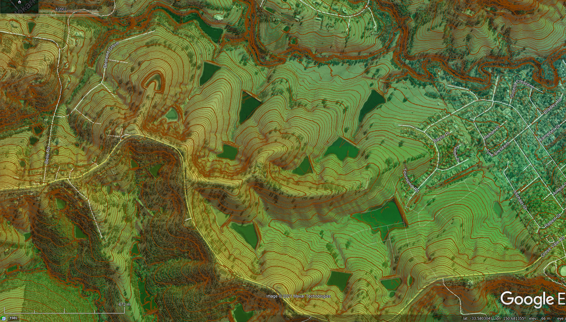
The following image is a screen grab from Google Earth after loading the DEM and 1 m contour KMZ files. It shows our family’s former property “Yobarnie“ near North Richmond, NSW. (See Figure 3 & 4 on page 36 of Water for Every Farm – Yeomans Keyline Plan). Note the book images were rotated ninety degrees anti-clockwise for the book. Standard mapping has north to the top and this is also the default with Google Earth.
The aerial photo is historical showing Google imagery from 2002 as shown in the top left time scale area. The green colour of the dam water is from the elevation colours of the DEM, where lower dams are darker green and higher ones are lighter green. The transparency of the DEM was adjusted in Google Earth so ass to see the underlying aerial imagery, whilst still being able to see the shading, which better reveals the shape of the land and make sense of the contours.
If you’d like me to help you see your land this way and discuss the development of your land, that would be great. That is what Keyline Designs Mapping Service is about. I don’t sell plows, that is my brother’s business.
If you have any questions about my services and/or the content of my book, please give me a call on 0418 745 120.
Keyline Designs Mapping Service charges a retainer of $374 inc GST. The retainer covers data sourcing and processing, map preparation time and supply of the KMZ files. Then we can schedule a Zoom, phone or Skype discussion about the maps and potential they reveal. The online consultation rate is $275 per hour inc GST.
Off-line design and map preparation work is invoiced at $253 per hour including GST.
To proceed, simply request a retainer invoice and advise the location of the property.
I’ll produce the map files for you after the invoice is paid and send you the KMZ files for you to consider prior to our discussion.
During the online consultation, I usually share my screen so we can be on the same page as we investigate and discover the development potential of your land.
![]()
Keyline Designs
1/69 Falconer Street, Southport, Queensland 4215 AUSTRALIA
Mobile: 0418 745 120
Email:info@keyline.com.au
![]()
Counter started Feb 1998 You are visitor number:
![]()
OR