
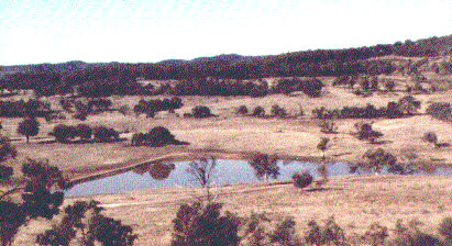
Keyline plans for the control and redirection of run-off water, where ever practical, into super-sized farm dams for later use by gravity powered rapid flood irrigation.
Keyline is the natural way to defeat the menace of soil erosion and salinity. It achieves this as an incidental to total landscape betterment.
One of the primary objectives of Keyline planning is to enhance the swift development of deep biologically fertile soil - living soil. This is achieved through a systematically designed landscape. Developing and deepening the soil's biological fertility will rebuild the soil structure and reduce run-off.
Keyline methods increase the "field capacity" of the land. It will quickly absorb and hold more water. The extra humus and depth of soil prevent the leaching of nutrients including salt.
The soil responds quickly to Keyline treatment and management techniques. Biological fertility and structural stability soon surpass undeveloped soil.
The cultivation, irrigation and stock management techniques of Keyline accelerate the natural process of living soil formation. Conversion of subsoil into topsoil may, under natural conditions, occur at 10 to 15 tonnes per hectare each year. On Keyline farms it can be 10 to 15 hundred tonnes per hectare each year during the two or three years of conversion. Deepening the topsoil by 10 to 15 cm (4 to 6 inches) achieves this result. A practical short term goal is to deepen the living top soil to around 30 to 45 cm (12 to 18 inches).
Cultivation furrows, even small ones will influence the direction in which run-off water flows. Only Keyline pattern cultivation delays the concentration of water in valley areas. It tends to keep run-off water on the ridge shapes. Keyline pattern cultivation looks like an amplified contour pattern. The pattern of furrows slope down from the valleys to lower areas of the adjacent ridges increasing the moisture absorbed on the ridges and reducing the concentration of water in the valleys. The soil is sweetened by the aeration that occurs with the tyned cultivation.
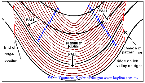
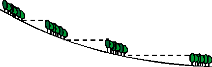
This contour diagram show a primary ridge with Keyline cultivation
designed to drift the first flow of rainfall run-off towards the
centre of the ridge. The blue arrow heads show the direction surface
flow will tend to move. Though the lower lines parallel the contour
they progressively develop a toward the centre of the ridge slope
as cultivation proceeds up the ridge. Note that ridge pattern
cultivation does not extend into the valley. Significant valley
shapes are cultivated differently to achieve the same water controling
effect. Details in the book "Water for Every Farm - Yeomans
Keyline Plan" Book Information
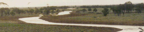
The two common methods to flood irrigate undulating country are "contour bay irrigation", which uses banks and terraces, such as for rice paddies; and "wild flood irrigation.
The development of Keyline Pattern Cultivation enabled wild flood irrigation to become fully controlled irrigation. It also enabled the rate of irrigation to be greatly increased. This unique pattern of cultivation made practical the low cost watering of undulation country and hilly lands.
"Keyline Pattern Irrigation", from a single channel, can water with flow rates of two megalitres per hour. This flow will water about four hectares per hour. Soil wash is minimal because the pattern of cultivation controls the flow of the irrigation stream after it leaves the excavated channels.
Psalm 65:10
You water its ridges abundantly,
You settle its furrows;
You make it soft with showers,
You bless its growth.
In flat country Keyline is often more efficient. The storage ratios
of farm dams are better in flatter country, resulting in more
water being stored for each unit of earth in the wall. In suitable
flat country, the unique "Keyline Contour Irrigation Channel"
has enabled: "Flood-Flow Irrigation" the fastest, fully
controlled, one man, gravity powered, irrigation in the world.
Flows rates of around ten megalitres per hour enable irrigation at the rate of 20 ha (50 acres) per hour when applying 50 mm of water.
Traditional slow flood irrigation methods used in most large scale irrigation schemes drown aerobic soil organisms, cause crop deterioration and promote salinity.
The slow application of flood irrigation water is not part of sustainable agriculture.
![]()
One of the important tasks of your Keyline Designs consultant will be to provide you with real data on your property's potential so that you can avoid mistakes and be able to initiate further development with confidence. Keyline will dispel illusions and reveal unsuspected relationships and define the potential.
The design process is based on the Keyline Scale of Permanence, which provides a priority guide for the various factors considered in the design of the landscape.
Keyline planning usually begins in the office with information derived from any topographical (contour) maps of the area. A topographical map indicates the vertical relationships between the features of the landscape. Based on this initial assessment key constraint points are selected and preliminary designs can be formulated.
Then during the on-site survey of the property, contour or grade lines will be pegged, as required from the key points previously selected. The starting project or first stage of the plan is usually pegged out. Dam sites are chosen and surveyed for volume calculation. Irrigable areas are revealed and pegged.
![]()
If you would like to read about of a current example of Keyline
Designs
Click here to go to an Example Property Murgon, Qld
![]()
The benefit clients derive from the consulting service increases proportionately with their knowledge about the principles of Keyline and the words (jargon) used to describe the landscape.
The latest Keyline book is "WATER FOR EVERY FARM - Yeomans Keyline Plan". This is a fully revised and updated rewrite based on the original "Water for Every Farm" by the late P. A.. Yeomans This new edition incorporates additional new information and is much easier to read. Measurements are in both Imperial and metric. Many of the diagrams have been redone and additional colour photos are included with all the original photos, from "Water for Every Farm using the Keyline Plan". The application of Keyline principles to urban design is also in this book in the form of excerpts from "The City Forest" (1973), which it is now out of print. The application of Keyline designs to urban areas includes storm water storage, contour roads and cleansing of city effluent in the deepened soil of Keyline city forests. This book is available direct from Keyline Designs or booksellers. The last chapter in it has some information on this consulting service.
![]()
As mentioned above, Keyline design pays particular attention to the vertical relationships of important features within the landscape. An important aid to the design is an accurate topographical (contour) map.
Topographic maps (sometimes called army maps) are drawn to a fixed scale and show features like creeks, roads, contour lines, spot heights, buildings, dams, etc. Such a map can save hours and possibly days in the assessment process. Maps at a scale of 1 in 10,000 are the most detailed that are generally available, although 1 in 100,000 or 1 in 250,000 are usually better than nothing. Laminated topographic maps (contoured) and cadastral plans (property boundaries, etc) will cost you about $30.00 if the property is covered by a single sheet overlay. The contour interval of these maps is usually about ten (10) metres. This is a significant limitation to property planning. Keyline Designs mapping service can help solve this problem.
The various State Departments of Mapping and Survey are very helpful. Besides the laminating, which they don't do, they may draw your property boundaries onto the topographic map for you. In Queensland this can be pre-arranged over the phone through Sunmap in Brisbane and the appended maps picked up or posted. If necessary the owner or manager can add the property boundaries to the topographic map themselves. When you're sure that the boundaries are accurate, have the map enlarged and laminated. Thus producing a durable map onto which design information can be placed. Transparent overlays assist planning.
Enlarged aerial photographs are useful. So to are overlapping aerial photographs as these can be coupled into a stereo pair enabling a 3D view.
Orthophoto maps are contoured aerial photographs. These are excellent and for more information on these maps check out... Keyline mapping service. .
If you are unable to obtain a suitable contour map, we may be able to assist you. Naturally we will require detailed information on the location of your land.
Climate and seasonal work loads may be a factor for consideration; also the likelihood of others in your area being interested in Yeomans Keyline Designs. On occasions Ken Yeomans will address seminars, Landcare meetings and field days upon request.
(1) Pegs
A bundle of fifty pegs, survey marker stakes, should be available on the first day although two or three hundred pegs are commonly used during the first three days of the design process.
The recommended length for most of the survey pegs is 1250 mm (4 feet).
The consultant often has available fifty fibreglass rods, 1250 mm by 10 mm, as are commonly used for electric fencing. Fifty of these pegs cost $150.
When used, timber pegs should be 0.9 or 1.2 metres (3 or 4 feet) long, pointed on one end and painted white for about 20 cm (8 inches) on the other end. Such pegs made of 25 mm square (inch by inch) timber and sell for about $90.00 per hundred ex Brisbane, Queensland.
Short temporary markers may consist of about 500 mm lengths of heavy plain wire with a loop twisted onto one end onto which bright flagging tape is attached.
Up to 20 star steel posts are often useful as permanent sighter pegs. However star steel posts are too heavy and cumbersome for general survey use.
(2) Helpers
It is naturally preferable for the owner or manager to accompany the consultant during the survey. One or two extra people can help at different stages of the pegging. When pegging the line for a graded channel two more people can speed up the process. One carries and hammers in the pegs and the other anchors the end of the measuring cord. Interested neighbours and or family members are suitable for this task.
Contact Keyline Designs via Email
![]()
Keyline Designs. PO Box 3289 Southport Qld 4215 AUSTRALIA.
In Australia phone: 07 5591 6281 - Fax: 07 5527 0847
- Mobile: 018 74 5120 International phone +61 7 5591 6281 - Fax
+61 7 5527 0847 - Mobile +61 18 745 120
Keyline Designs discount the recommendations by Australasian Register of Agricultural Consultants.
The investment for the consulting service is based on hourly rates, plus travel and accommodation expenses if incurred. If you provide transport, accommodation, pegs and helpers there is no other charge for the service. (Click here for details about Keyline consulting fees).
![]()
Counter started Feb 1998 You are visitor number:
![]() Back to Keyline Designs Homepage
Back to Keyline Designs Homepage
© Ken Yeomans Keyline Designs